

|
|
|
|
||
|
|
|
|||
|
|
|
|
|
|
|
|
|
|||
|
|
|
|||
|
|
||||
|
Scull and Heap's map was originally published in Philadelphia in 1752 by
Nicolas Scull. Scull was the first member of an American family to
engage in cartography as a business. Apart from his map of Philadelphia,
he is also well known for his general map of the province of
Pennsylvania, the first of the province to be printed on the North
American continent. George Heap was an important American surveyor and engraver who in 1748 attained the position of surveyor General to Thomas Penn. The Penns required an accurate map of their lands as they were concerned with promoting settlement and development in the region. It was left to George Heap to prepare the map in collaboration with Nicolas Scull. Philadelphia resembles a waffle iron of streets and contains little detail. Only one public building , the Courthouse at Second and Market Streets was identified. This was done to mark the location from which distances were measured and set out in the table. Scull was directing attention to the country lying outside the grid area. It is the Parts Adjacent to the city which makes the map rewarding. Extending out from the city, upwards of eight miles, Scull and Heap plotted in the roads and the names of many people who lived on them. Rivers and creeks are shown, as well as villages and ferries, islands in the Delaware, and other points of interest. In the upper left quadrant, note the Lancafter Road (Lancaster Road) and the identification of such places as the Merrion Meeting (Merion Friends Meetinghouse), Tunis (General Wayne Inn), Tunis (Anthony Tunis), Griffiths (John Griffith), Evans (Robert Evans), and Roberts (John Roberts of Pencoyd). As a guide, in the lower right hand quadrant there is placed a table of The Distances of particular Places, in this Map; from the Court Houfe. Take note of the entry Merion Meeting N.W. which is identified as being located at 7 miles and 5 furlongs (a surveyors furlong is equal to 660 feet in length). The original 1752 edition of this map had a great influence on later map makers and was copied and re-issued throughout the latter part of the 18th century. This version of the map was printed in London using black ink on white paper and included in the August 1753 edition of The Gentleman's Magazine which was a popular news journal published monthly throughout the 18th century. In England, around 1900, it was popular to hand color older maps; therefore, it was probably around this time that this original engraved map was colorized. |
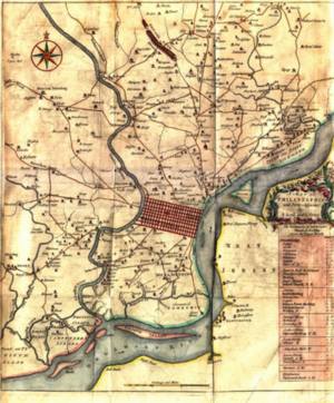
See a low-resolution image of the map (222K) | |||