| |  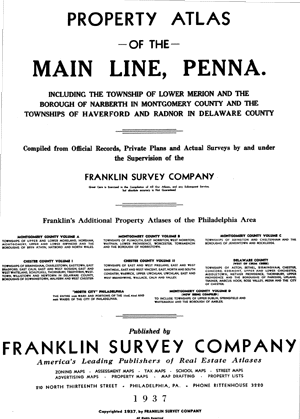 | | 
Property Atlas of the Main Line, Penna. Including the Township of Lower Merion and the Borough of Narberth in Montgomery County and the Townships of Haverford and Radnor in Delaware County.
Complied from Official Records, Private Plans and Actual Surveys By and Under the Supervision of the Franklin Survey Company. Published by Franklin Survey Company, 210 North Thirteenth Street, Philadelphia, Pennsylvania. 1937List of Plates Index MapArdmore East (Plate 11)
Ardmore R.R. Station (Plate 12)
Ardmore South (plate 26)
Ardmore West (Plate 25)
Bala (Plate 5)
Bala and Cynwyd (Plate 6)
Belmont Hills (Plate 8)
Bryn Mawr East (Plate 16)
Bryn Mawr R.R. Station (Plate 14)
Cobbs Creek (Plate 27)
Darby Rd. (Plate 31)
Gladwyne (Plate 21)
Hagy's Ford Rd. (Plate 19)
Haverford College (Plate 24)
Haverford East (Plate 17)
Haverford R.R. Station (Plate 13)
Lafayette Rd. (Plate 22)
Llanerch (Plate 28)
Manoa (Plate 30)
Meeting House Lane (Plate 7)
Merion (Plate 4)
Mill Creek area (Plate 18)
Mt. Pleasant Rd. (Plate 23)
Narberth R.R Station (Plate 10)
Oakmont (Plate 29)
Overbrook & Merion R.R. Stations (Plate 3)
Penn Valley (Plate 9)
Radnor and St. Davids R.R. Station (Plate 33)
Radnor Chester Rd. (Plate 35)
Rosemont R.R. Station (Plate 15)
Villanova R.R. Station (Plate 32)
Waverly Rd. (Plate 20)
Wayne R.R. Station (Plate 34)
Wynnewood (Plate 1)
Wynnewood R.R. Station (Plate 2) | |