
| | | | ||
| | | |||
| | | | | |
| | | |||
| | | |||
Introductory Comments. This document is from the John Roberts (the malster) Family Collection of The Lower Merion Historical Society having the Accession Number "R0101". It is an unpublished and incomplete manuscript by Perry L. Anderson and Adam Sutton. The document was drafted in 1888 and was written in long hand in a booklet format. Over the summer months in 2001, a group of volunteers took on the project of transcribing this text which is presented below. Those who worked on this project were: Philip and Elizabeth Eidelson of Merion, Ann Bagley of Merion, and Gerald and Denise Francis of Bala Cynwyd. All of us made every effort to accurately transcribe the text, but like any handwritten text, occasionally there were words that were difficult to decipher. When reading through the text, the following editorial conventions were employed:
September 13, 2001 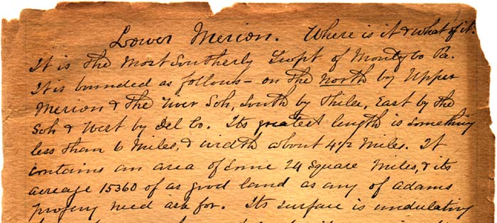 It is the most southerly Township of Montgomery County Pennsylvania. It is bounded as follows - on the north by Upper Merion and the River Schuylkill, south by Philadelphia, east by the Schuylkill and west by Delaware County. Its greatest length is something less than 6 miles, and width about 4 1/2 miles. It contains an area of some 24 square miles, and its acreage 15,360 of as good land as any of Adam's progeny need ask for. Its surface is undulating but not so much so as to make it undesirable for agricultural purposes. The soil is what may very properly be called a rich loam, and beneath its surface is to be found, in different localities various qualities of stone in abundance and suitable for all purposes. So far as has yet been discovered, it seems to be barren of precious ores. Specimens of Iron Ore have been mined to a limited extent near what is called the black rocks a short distance west from Merion Square, but not of sufficient richness to warrant any expenditure of capital in its production. A bed of excellent Soap Stone was discovered some several years since, a little north west from the mouth of Mill Creek. The natural products of her soil compare favorably with any other portion of the county or state. The greater portion was covered with wood at the time of its occupancy by the red men. We think it not too much to say, that there is at least one hundred varieties of wood growing on her soil today that is indigenous to the same. Its flora exhibit is not to be compared in extent to some more Southern localities, but abounds in very much that will repay the naturalists for excursions within her borders. It is beautifully diversified with hills and dales and from some of the former are to be had views of unsurpassed grandeur. Over its surface, and through its miniature valleys, meander quite a number of streams of good soft water. So numerous are the rivulets [a small stream] that there is not a single farm of any magnitude without one or more fountains of the living crystal as Rebecca went to procure when she met Isaac. The largest stream within her bounds is known as Mill Creek. This stream has its source in Delaware County and from a spring near Villanova Station on the Pennsylvania Railroad, and one contiguous to what was once known as the Balm(?) Tavern. It is a circuitous and rapid stream about 6 miles in length, and receives its supply from quite a number of small rivulets [a small stream] coursing into it from different directions and propels quite a number of manufacturing establishments that will be noted as we progress with our story. Gethley(?) or Rock Hollow Creek is also a stream of some importance, of some 2 miles in length, having its source at springs on premises owned by William Kirk and the Mayer(?) Estate, and empties into the Schuylkill at what is now known as the Ashland Paper Mills, formerly Anthony Levering's Mills opposite Manayunk. Cobbs Creek of Delaware County takes its rise in this Township on the premises now owned by Mrs. Martha G. Anderson near Haverford College Station. There are other streams of less magnitude that have been named by map makers, but the cognomens [nicknames] given by such parties has not been accepted or adopted by the people they have refreshed and made glad, and to speak of them today by such names only serves to provoke a smile among the oldest inhabitants. The exact time of organization of [the] Township is one of the matters of importance that writers and historians have failed to ascertain with any degree of certainty. It is a well known fact that Lower and Upper Merion Township were one municipality as it were and was all known as Merion. The earliest mention I have ever come upon of Lower Merion was somewhere about 1683. William Penn's Surveyor General Holme in his Map of Pennsylvania made in 1681 has Lower Merion laid off just as it is at this day. See map in frontispiece, which is, so far as yet known, the oldest of State and Township in existence. From this we find that all the lands were taken up and owned by fourteen individuals and their colonies as follows: John Holland 2,500 acres, Christopher Pennock, William Wood, William Sharlow 2,500, Edward Jones and Company of 17 families, Thomas Ellis and Company, John Humphrey and Company, Daniel Medlieot(?), John Roberts, Charles Lloyd, Thomas Lloyd, Jonah John, Richard Davis and John Bevan. The name given the Township was derived from Merionethshire a county in Wales from which a greater portion of the early settlers emigrated. Quite a number of Welshmen together with a few Englishmen purchased from Penn in England a tract of 40,000 acres of land, a large portion of which is in Lower Merion, some in Haverford and Goshen Townships. The names of the first purchasers are given on the copy of map as made by Surveyor Holme. Some few of them were English merchants - William Sharlow and William Wood took up some 5,000 acres, but never came to this country to occupy it. By a reference to the map it can readily be learned that the settlers were Welsh from their names and that they settled as early as 1683-84 and their number was augmented yearly. A man named Oldmixos(?), who was here as early as 1708, in writing of this Welsh Tract and the people, says it was then "very populous, and the people very industrious; by which means this county is better cleared than any other part of the County. The inhabitants have many fine plantations of corn, and breed abundance of cattle, inasmuch as they are looked upon to be as thriving and wealthy as any province - and this must always be said of the Welsh, that wherever they come 'tis not their fault if they do not live well, too; for they seldom spare labor, which seldom fails of success." The greater part of these pioneer settlers belonged to the Society of Friends and very early arranged to have meetings for public worship. If memory serves me right, they "assembled together in one place agreeable to the divine inspiration as early as 1683." An account of erection of Meeting House is given elsewhere under heading of Meeting Houses. Benjamin Humphrey settled in 1683 and became quite a prominent citizen. He died November 4, 1737 aged 76 years. A David Humphrey was commissioned a Justice of the Peace November 22, 1738. Some of the descendants of these families are still living and continue to reside in the locality of first settlement, and it is from this family that Humphreysville took its name, and which was the nucleus of Bryn Mawr. The Roberts family were also among the pioneer settlers. There appears to have been some two or three branches of this family. John Roberts of Llyn(?) in the County of Carnarven was led to embrace the tenents of the Friends who met for worship near Balla in Merionethshire about the year 1677 and continued to worship with them until the year 1683 when he "transported himself with many friends for Pennsylvania where they arrived the 16th day of the 9th month 1683 being then about 35 years old and settled myself in the place where afterwards I called Pencoid in the Township of Merion which was afterwards called by them being the first settlers of it, having brought with me one servant man from my native land and fixed my settling here, I took to wife Gainor, daughter of Robert Pugh from Llyndedwydd near Bala." Roberts took title from William Penn to a tract of ___ acres; a part of which has come down to his descendants, without any change of title especially that part now owned and occupied by George B. Roberts of railroad fame, and is believed to be the only piece or parcel of land in the Township that is held with the original title. Hugh Roberts a noted Friend and preacher of that Society came from Wales in 1684 and traveled extensively proclaiming the truth as he understood it, and it is said that "his services were effectual to the people." He departed this life in the year 1702, and was interred in the Merion Meeting grounds. It seems an unfortunate circumstance that no stones mark the resting place of so many of the early settlers and godly men who were so useful to their fellow man in providing others with good works. There was a Robert Jones who purchased of William Penn in England in 1682, a tract of 500 (acres) which was also in this Township. The time of his immigration I have not been able to ascertain. From well preserved records we are informed of his being appointed a Justice of the County Courts in June, 1715, which office he held a number of years. Edward Jones was another early Friend who was given to good deeds and held above par by his neighbors. He departed this life in February 1737 aged 82 years. Family records inform us of Jonathan Jones having been brought to this County when but 3 years old, and continued to reside on the tract possessed by his parents, and known as Wynnewood, until he died which was on June the 30th, 1770 age 91. He too was laid away at Merion Meeting grounds. Robert Owen a very prominent and influential minister among the Friends came over from Wales in 1790. The days of his pilgrimages and ministry were of short duration in the land of his adoption, he having died in July 1797 and awaits the summons from on high in Merion grounds. Griffith Llewellen was also a Welshman and came here about the year 1693 also his brothers Morris and David. These men were highly educated and intelligent gentlemen, public spirited and led exemplary Christian lives. Griffith was commissioned a Justice of the County Courts in April 1744 and continued in said office until the time of his death in 1750. These men assisted with their own labor in the erection of Lower Merion Friends Meeting House in 1695. The house on premises owned by Joseph Ezra(?)'s estate was built by Griffith the year of his death. He was buried at Haverford Friends Meeting. From time faded records written for the Proprietor of the Colonies in 1734, we find the landowners of the Township to number 52. Their names are as follows. Several of their descendants are living among us today and nearly all were Welsh. John son of Mathias Roberts, Hugh Evans, Robert Jones, Robert Roberts, Robert Evans, Reese Price, Edward ap Jones, Abel Thomas, Benjamin Eastburn, Jonathan Jones, William Havard, Richard Hughes, Morris Llewellen, Benjamin Humphrey, John Humphrey, Joseph Williams, Reece Thomas, William Thomas, Peter Jones, Humphrey Jones, John Griffith, Catherine Pugh, Reece Phillips, Joseph Tucker, James John, Thomas John, John Lloyd, Griffith Llewellen, Robert Roberts, David Jones, William Walton, David Davis, Joseph Roberts, John Roberts, David Price, Isachat(?) Price, David Price Jr., Lewis Lloyd, John David, Robert son Peter Jones, Thomas David, John Evans, Eleanor Bevan, Owen Jones' plantation, Evan Harry, Nicholas Rapy, John Roberts carpenter, Evan Reece, Samuel Jordan, James Dodmead(?), Edward Edwards and Garret Jones. More particular mention will be made of some of these men under another heading - that of "Men of Prominence." It would like to be vain and presumptuous to attempt to assert who was the first white person to tread upon her soil, as it would be the very wildest kind of conjecture. This Township is traversed by a greater number and mileage of roads than any other of the County, especially, the part lying most contiguous to the Philadelphia boundary. The earliest assess books we have been enabled to find, were for the year 1785, John Roberts assessor and Benjamin Brook and Richard Tunis assistant assessors. We ascertain the lands to have been owned as follows: John Price, farmer 194 acres Other taxable inhabitants numbers 111 Two residents of Township owned real estate not situated in Township - namely: Lewellyn Young, an unimproved lot on Arch Street between South 6 and 7 Philadelphia 49 1/2 feet front, 306 deep. Widow Morgan owned 300 acres in Westmoreland County. The heaviest taxpayers: The principal ones of lower rates were as follows - Total amount of assess amounting to 54,775 pounds, 13 shillings, 11 pence The different professions or callings of the people number 21 - Single men not given any calling 33 Negro slaves owned in the Township in 1785 numbered 6; owned as follows - The only person having a vehicle for pleasure is William Stadelman, and that is a "chair." Added Note: The "chair" mentioned in early assess books was a two wheeled vehicle on leather springs with a stiff top. After a time there was an improvement made on the top which allowed it to be thrown back as the present full top buggies and was then called a gig. These were supplanted by the four wheeled "Dearborn Wagon" having at first a wooden(?) spring and were considered quite an improvement over the chair and sedan for marketing purposes. The steel or elliptic [shaped like an ellipse] spring has been introduced within the memory of the writer. The early method of conveying marketing to city was by means of hack-horses having a hamper sack thrown over in front or rear of saddle with pockets in each end in which was put the vessels containing the merchandise. Stage Coaches were put upon some of the main arteries of travel for carrying passengers and light parcels. The Conestoga Wagon were brought into requisition for heavy merchandise. Then it was that the highways were required to be put in better order than heretofore. Such luxurious modes of travel as are enjoyed at this day were not dreamed of by the primitive fathers. The number of horses as per same book 244 The industrial establishments were as follows - In 1850 - For the year 1887, the assessment showed as follows - In order to facilitate travel, and assist the establishment of places of industry and to conduce to the social well being of the sparsely settled inhabitants, one of the first steps in such a direction was the establishment of roads. From colonial records we find the Haverford Road is (to) have been about the first [in] 1703. Starting from "near Haverford Friends Meeting and continuing to Middle Ferry at Philadelphia," now known as Spring Garden or Callowhill Street Bridge. The road from High Street Ferry, now Market Street and known as the Old Lancaster Road November 23, 1741. The Ford Road leading from a point on the River Schuylkill a short distance below what is now the stone bridge at the Falls of Schuylkill where was a ford and continuing on up the hill through what is West Fairmount Park to 5 Points to a point now known as Merionville and from thence to the Lower Merion Friends Meeting. I have been unable to find records of, but it was established very early in the 17th century. It was by this route the early Friends from Gwynedd traveled when visiting the Friends Meeting at Merion. There is no data extant that we have discovered that would warrant us in saying Penn frequently traversed it and rested at certain points. The Old Gulf Road commenced at a point on Old Road near the 7 Mile Stone where is now the residence of Misses Tillie and Harriet Young and continued on down what was know for many years as McClenaghan's Hill, now Hugh Burgess place on past John Roberts Grist Mill, following on up the creek to Scheetz Paper Mill and up the hill and out past Harriton Estate, now Mrs. Naomi Morris, once owned by Charles Thompson First Secretary of the American Congress to what is now the Lower Merion Baptist Meeting, thence to the right continuing on to the Gulf and on to King of Prussia, thence to Valley Forge and from thence in after years to Phoenixville. Just when it was laid out is a matter of conjecture, but was doubtless prior to 1749. That part from Baptist Church to a point near Haverford College Station, now the entrance to Thomas Simpson's estate is also an enigma. It is upon this part the first Mile Stones appear having 3 balls carved upon them. These characters were intended to represent the counties through which the old road traversed - Philadelphia, Chester and Lancaster. Some writers of reminiscence have drawn so far upon their imagination as to say the characters represented apple dumplings Penn had eaten with the Indians during his peregrinations [traveling about especially on foot] through the County. Such a story is too idle to be entertained for a moment. It is not likely there was any fruit of that kind in these parts, and beside that the Indians were not well versed in the culinary arts. Their repast must have been of a very straightened character. In the year 1766 a road was laid out from John Roberts' Mill, now in ruins and owned by Lewis Robeson, on up the creek and up the hill to Merion Square, from thence to what was known as Youngs Hollow on to Rees ap Edwards' Ferry on what was known in after years as Youngs Ford, now some time after 1741 the Righters Ferry was laid out from Peter Righters' Ferry, now where Pencoyd Iron Works stand following southwesterly up the ravine to a point on the Ford Road near what is now known as the Wisconsin Hotel, or corner of Highland Avenue and Bala Avenue. In 1767 Anthony Levering petitioned for a road leading from his Mill, now Ashland Paper Mill at west end of Manayunk Bridge down the river to Righters' Ferry and over that road to where is now the stable of West L.H. Cass(?) Company, thence on up the hill through lands of Algernon Roberts to Ford Road and where is now the place called the 5 points to be called Levering's Mill Road. The viewers [surveyors] were John Jones, Jacob Engle, Jacob Morris, Jacob Knor, Jacob Keyser and William Miller. Length 2 miles, 124 perches, width 40 feet. In 1785 the first year after the organization of Montgomery County, Anthony Levering petitioned for a road from his Mill through lands of Jacob Jones and others to the Lower Merion Friends Meeting, which was granted. The first Turnpike road to be made in the State was the Lancaster. The Act of Assembly authorizing it, was passed April 9, 1772, constituting Elliston Robert(?), Henry Drinker, Jr., Owen Jones, Jr. Israel Whelen and Cadwallader Evans of Philadelphia and Edward Hand(?), John Hubley, Paul Zantzinger, Mathias Slough and Abraham Witmer Commissioners to see subscriptions and construct the same. It was commenced(?) the same year and completed in 1794 at a cost of some $7,500 per mile. Gates for the collection of tolls to be established upon the completion of each 10 miles after it has passed inspection of 3 disinterested persons appointed by the Governor for that purpose. The tolls were as follows - "for every score of sheep and hogs 1/8 of a dollar, for every score of cattle one 1/4 of a dollar, for every horse and his rider, or led horse, 1/6 of a dollar; for every sulky, chair, or chaise, with one horse and two wheels, 1/8 of a dollar; for every chariot, coach, stage wagon, phaeton, or chaise, with two horses and four wheels 1/4 of a dollar; for either of the carriages last mentioned, with 4 horses 3/8 of a dollar; for every other carriage of pleasure, under whatever name it may go, the like sums, according to the number of wheels and horses drawing the same; for every cart or wagon, whose wheels do not exceed the breadth of 4 inches, 1/8 of a dollar, for each horse drawing the same; for every cart or wagon whose wheels shall exceed in breadth 4 inches, and not exceed 7 inches, one 1/6 of a dollar for every horse drawing the same; for every cart or wagon, the breadth of whose wheels shall be more than 7 inches and not more than 10 inches, or, being of the breadth of 7, shall roll more than 10 inches is 5 cents for every horse drawing the same; for every cart or wagon of 12 in tread, 2 cents for every horse drawing the same. The same rates to be continued in proportion as road is completed, with authority to modify at any future time." Section 12 of same act reads "That no wagon or other carriage with 4 wheels, the breadth of whose wheels shall not be 4 inches, shall be drawn along said road between the 1st day of December and the 1st day of May following, in any year or years, with greater weight thereon than 2 1/2 tons, or with more than 3 tons during the rest of the year: that no such carriage, whose wheels shall not be 7 inches or being 6 inches or more, shall not roll at least 16 inches, shall be drawn along the said road between the said 1st day of December and May with more than 3 1/2 tons, or with more than 4 tons during the rest of the year: that no such carriage, the breadth of whose wheels shall not be 10 inches, or more, or, being less, shall not roll at least 12 inches, shall be drawn along the said road between the 1st day of December and May, with more than 5 tons, or with more than 5 1/2 tons during the rest of the year: that no cart or other carriage, with two wheels, the breadth of whose wheels shall not be 4 inches, shall be drawn along the said road with greater weight thereon than 1 1/4 tons between the said 1st day of December and May or with more than 1 1/2 tons during the rest of the year: that no such carriage, whose wheels shall not be the breadth of 7 inches, shall not be drawn along said road with more than 2 1/2 tons between December and May, or with more than 3 tons during the rest of the year: that no such carriage, whose wheels shall not be the breadth of 10 inches, shall be drawn along said road between December and May, with more than 3 1/2 tons, or with more than 4 tons during the rest of the year: that no greater weight than 7 tons shall be drawn along said road in any carriage whatsoever between December and May, nor more than 8 tons during the rest of the year; that no cart, wagon or carriage of burden whatsoever, whose wheels shall not be of the breadth of 9 inches at least, shall be drawn or (???) in or over said road or any part thereof, with more than 6 horses, nor shall more than 8 horses be attached to any carriage whatsoever, used on said road; and if any wagon or other carriage shall be drawn along said road by a greater number of horses, or with greater weight. There is hereby permitted, one of the horses attached hereto shall be forfeited to the use of the said Company, to be seized and taken by their officers or servants, who shall be at liberty to choose which of said horses they may think proper, excepting the shaft or wheel horse or horses. Provided said regulations may be altered by the By Laws." After the completion of this road it became the main artery of travel between the far west as it was considered then - Pittsburg and over it was transported all manner of merchandise. The mode of conveyance was by huge Conestoga wagons drawn by 4 and 6 horses. Trains of teams a mile in length have frequently been seen on their way to Philadelphia. Each gang of teamsters had their particular hostelry at which to stop for the night. The evenings were generally spent in a free and easy merry making. It was the custom in those days for nearly every man to imbibe his grog, as it was customary to call it, but it was a rare thing for men to make brutes of themselves as in these days of poisoned drugs. After trade had been diverted from this road many of the Hotel keepers relinquished the business, enclosed their houses and have their rooms rented out or devoted to other purposes. The major part of the inhabitants of the Township have no idea as to what number of way stations there were or what houses were used as such. An account of them will be given further on under their proper heading. Pennsylvania Railroad] The Legislature of Pennsylvania on 31 March, 1823 passed an Act incorporating a company to construct a railroad from Philadelphia to Columbia on the Susquehanna a distance of some 80 miles. Among the corporators named in the Act were the late Horace Binny and Stephen Girard of Philadelphia. "John Stevens was however, to be the master spirit of the enterprise." This was the first railroad chartered and built in the State and took its course of 5 miles through this Township. The charter was to continue in force for 10 years, and to be forfeited if the road after construction was permitted to become impassable for 2 years. In 1824 the Legislature passed another Act repealing the Steven Charter of 1823 and granted another for construction of a railroad but the charters were not carried out by those to whom they were presented owing to a want of enthusiasm among private capitalists. In 1827 the Legislature authorized [the] Canal Commissioners to make examinations for a steam road, and in 1828 were directed to create and put under contract a railroad from Philadelphia to Columbia via Lancaster, and complete the same within two years if practicable. Work was commenced upon this road as soon as possible and was completed to Columbia at an expense of $_____. During the year 1832 portions of the road were completed and cars commenced running upon it. The style of engines and cars in use at that early day was quite in contrast with those in use in these days of progress. The first cars were propelled by horses however and were regularly run between Columbia and Philadelphia. The time consumed in making a trip was about 9 hours, the horses being changed every 12 miles. The passenger cars were similar in construction to the Old Stage-Coach, only larger, the entrance being at the side, and driver was perched on an elevated seat in front. The first locomotive used on the road was of English construction and was called Black Hawk, after the celebrated Indian Chief and ran between Columbia and Lancaster. This engine was hauled from Philadelphia to Lancaster over the Lancaster Turnpike and was an object of wonder to the people living along the road. The day for the trial trip was all that could be wished for, for such an occasion, and great multitudes of people gathered from the surrounding country as spectators to the novel performance. Governor Wolf and the State officials put in an appearance at Lancaster upon that occasion and the excitement of the occasion was most intense. It was not until about 1836 that locomotives superseded horse power. The Schuylkill River was crossed by a wooden bridge and the ascent from that to the top of the hill to a point in the West Park at commencement of Chamounix Drive was by an Inclined Plane of some two thousand 800 feet in length and 187 feet rise. The cables drawing the cars were operated by stationary engines located at the top of the hill at the place indicated. This novelty was the occasion of hundreds of people visiting the Plane every Sunday for years. About the year this road was absorbed by the Pennsylvania Railroad, a new route was chosen from the western corner of the Township known as White Hall, to Market Street. The Reading Railroad then purchased the franchise of the Columbia from Philadelphia to said White Hall and used the tracks as far as what is now known as Belmont for the transportation of its cars, and in 185_ sold the tracks, engines and franchise of the miles of abandoned route to Messrs A. & P. Roberts of the Pencoyd Iron Works. After the road bed had been dismantled the property holders along the line fenced it in. Nearly all trace of the once famous, unprofitable road has been lost sight of except to some of the older inhabitants of the present day. The Reading Railroad skirts the north-eastern boundary of this Township its entire width of some 6 miles. It extends from Philadelphia to the different coal regions of Schuylkill County and was chartered April 4, 1833, and put under contract the following year. Some two miles and 1/2 north of the city line this road passes through a rocky excavation known as Flat Rock Tunnel some 960 feet long about 20 feet wide and 18 feet high, and at its deepest place is nearly 80 feet below the surface. The entrance at the southern end is built of dressed stone and at the top of the arch is a stone with the following inscription cut upon it, Philadelphia & Reading Railroad opened between Philadelphia and Reading the 9th day of December 1839, President, Eliha Chauncey; Managers, Coleman Fisher, William H. Keating, M.S. Richards, John A. Brown, William C. Emlin, Charles P. Fox; Engineers M. & W. Robinson. This road is well known in these parts as an anthracite coal carrying road of the State. The Pennsylvania Schuylkill Valley Railroad is the outcome of a merger of divers [various] charters of divers [various] railroads and takes a diagonal course of about a mile and 3/4 through the Township. The construction of this road was commenced in 188_, and was completed as far as Norristown in ____ and has proven quite a convenience to the people residing along its line, and contrary to expectations, has been the means of advancing real estate lying contiguous there. Inasmuch as the Schuylkill Navigation skirts the eastern corner of the Township for about a 1/2 mile, it may not be uninteresting to the reader to know of the river not being navigable for boats of commercial burden until after the construction of the various dams and canal. The Act of incorporating the Schuylkill Navigation Company, passed March 8, 1815, and to insure the completion of the undertaking, work was to commence at each end. The project was completed in 1826. The cost of construction was $2,966,180. In 1818 it was sufficiently completed to allow of the passage of a few boats of light tonnage, from which tolls were collected amounting to $230.00 the total of years receipts. The price of freight from Philadelphia to Reading was 12 1/2 cents per CWT and by land transportation 40 cents. In 1842-43 alterations were made in the various locks to permit of the passage of boats of greater tonnage and river channel improved below Manayunk at a cost of many thousands of dollars. William Scull, in his map of 1770 has denoted coal at some 3 places in the vicinity of Pottsville and also on the Mahanoy Creek, yet some time elapsed before much attention was given to mining it as an article of commerce. The first coal sent by water to Reading that the writer has learned of, was by Abraham Potts on flats carrying a few tons in 1821-23 as far as Reading. In 1824 he had a boat built carrying some 28 tons as far as Reading. The first boats to carry any amount of freight were long and narrow, sharp at both ends, and carried from 50 to 150 barrels of flour and were only used in a time of extraordinary high water and floated down with the current. They were returned by man power and it mostly took 4 men to propel them, which they did by the use of very long poles shod at one end with iron. This work was very laborious and kept the men on the move without interruption. The writer remembers seeing such performance. In the earliest assessment we have been enabled to find, that of 1780, there are but 3 persons noted as keeping hotels, namely - David Briggs, The Three Tons, now Green Tree on Gulf Road, William Stadelman, The Black Horse on Lancaster Road and City Line, now abandoned, and Abraham Streeper, [The] General Wayne adjoining Friends Meeting. These and the Prince of Wales now the residence of Dr. Joseph Anderson were noted places of entertainment before the Revolution. Other houses were opened and closed from time to time at subsequent periods. The names that some were known by have been forgotten. A hostelry was once kept at the residence of the late Thomas Vaughan, and on property now owned by Charles Halberstadt. The Flag was where is now the Pike entrance to Seminary of St. Charles Borromeo; Spring Mill now abandoned, this house seems to have been opened by William Torbert and kept by divers [various] others, among the number was Philip L. Kriekbaum, Reece Harry and George McClenachen. The William Penn was where is now the residence of G. P. Shortridge. The 7 Stars was at the residence of the late Charles Kugler, but now the property of A. L. Snowden opposite the 7 Mile Stone on [the] Turnpike. The Red Lion has continued open without interruption and has always retained its original name. The Balm(?) was on the old road near Henderson's Store. Righters The Dove on Gulf Hill below D. Stackers residence and now the property of Mathias Walker. Merion Square was opened shortly after the Revolution and has been a place of considerable note for petty squabbles and where some notorious litigation has started. Further particulars will be given further on. The Ashland House was the homestead of Anthony Levering for many years and was first opened as a hotel by James Bradley and he was followed for some years by Samuel Metzler. It is now the residence of S.A. Rudolph, White Hall was opened by Jacob Castner. This house is now the property of the late Charles Auther' Estate. A tippling house [where intoxicating liquor is sold and drunk] was opened at the west end of Tow Path Bridge and was run for a number of years by divers [various] persons and tended toward the demoralization of the community. A large house was erected at Pencoyd by Aaron Wirth, known as the Continental and was run a few years by the owner and Fritz(?) Mirkle and had no better effect upon the morals of the community than the last named. It is now owned by the Pencoyd Iron firm and used as a store, dwelling and pattern room. Michael W. Monaghan opened a drinking saloon near by in the year ____ and continues to supply the thirsty workmen of the Iron Works with liquid fire. a liquor store was opened near by a few years since by Michael Murphy and is still in full blast. The Wisconsin Centennial State building was bought by Mr.(?) Simes of Philadelphia who had it moved bodily to its present location on Montgomery Avenue and had it opened as a place where the thirsty could be supplied. It has been run by _____ and D.A. Titlow, the present proprietors. The Ardmore Hotel was opened and continues to be presided over by Reuben G. Smith. A tavern was once opened at Merion Square many years ago by a John Stilwagon but was not continued very long; the license being revoked owing to proprietor being indicted for keeping a tippling house [where intoxicating liquor is sold and drunk]. At June session 1789, Abraham Streeper was indicted for "keeping a tippling house" [where intoxicating liquor is sold and drunk]. Fine paid and license continued. Belmont Driving Park Hotel was licensed 18__ and is continued as a drinking place. William G. Lesher of Academy has a license for a liquor store. The Flat Rock Hotel was quite a place of note at one time, nearly a century ago and was kept by Grow and his descendants as long as it was continued as a hostelry (???) (???) kept a drinking house for some years on River Road near Manayunk Bridge but abandoned the traffic some years since. The above mentioned are about all the places that have been and are still kept for the dispensing of liquors by the small or otherwise. The names of persons applying for license since the organization of Montgomery County in 1784 are as follows - The Black Horse continued to be kept by one family longer than any other place of the kind in the Township. The Red Lion, General Wayne and Flat Rock were the next places that were kept in some families any length of time. [a flood or overflow of a river caused by heavy rains or melted snow] The first record of heavy freshets in the Schuylkill River that I have discovered were as follows: Ice freshet February 1733 and was very destructive cutting away "great trees and carried off 2 flats and water 2 1/2 feet on ground floor of Joseph Gray's Middle Ferry." The second was in February 3rd, 1737 and the ice backed up through heavy rains melting the snow. "The water rose near 6 feet on the floor of JosephGray's house at Middle Ferry." Another occurred in the Fall of 1839 in consequence of heavy rains and was called by the old settlers along the banks, the Pumpkin freshet. During the winter of the same year a destructive ice freshet occurred. One occurred on the 8th of October 1869 and carried off the two Manayunk Bridges and was very destructive to property along the shore. Another ice freshet occurred in the winter of 1872 but pass off without any great amount of damage. The freemen of Lower Merion, and other parts of the County, previous to the Revolution were obliged to go to Philadelphia to cast their suffrages at the Inn opposite the State House. In the year 1778 the elections for this part of the County were ordered to be held at the public house of Jacob Coleman, in Germantown where they continued to be held until changed by an Act of Assembly September 17th, 1785. They were then ordered to be held at the Court House in Norristown. In March 31st, 1806 this Township became a separate district and elections were ordered to be held at the public house of Titus Yerkes - the General Wayne and is still held there for the Lower District. The population having increased to such numbers as to make it almost impossible to have the vote recorded in the time allowed by law for the polls to be kept open, another polling place was directed by the court to be held at the Merion Square Hotel. In the year 18__ another poll was established at Bryn Mawr, one in the Lower East District at the private house of John Winchester on River Road opposite Manayunk for the accommodation of the freemen of Pencoyd and in 18__ another was established at Ardmore making five Districts in all. The voting population of the Township now numbers about 1400. The two oldest buildings in the Township at the present time are the Friend Meeting and [a] house on [the] estate of Owen Jones on the Old Lancaster Road between Libertyville and Ardmore both having been built in the year 1695. There is a building now owned by Croft at Mill Creek, a part of which is much over a century and the stone dwelling on the estate of Joseph Ezra was built by Griffith Lewellyn in 1750. Part of the General Wayne Hotel and the abandoned Black Horse Hotels both antedate the Revolution, also part of the homes now owned and occupied by Dr. Joseph W. Anderson at Ardmore and the Green Tree Hotel on the Gulf Road. Part of a house, now owned and occupied by S.A. Rudolph was built by A. Levering early in the 17th century. Also, the house now owned by Theodore Ott near entrance to West Hill Cemetery and the farm house on estate of A.S. Roberts. In the hope of adding interest to what may be said about ferries it has been thought best to give some little account of all that have been established on the river from Philadelphia to Conshohocken. The first nearest the mouth of the river was Penrose Ferry and was established in 18__. The next was Gray's Ferry. The Schuylkill was forded by the early settlers just below the Falls Bridge and was one of the first places of intercommunication. Then again at the place where Peter Righter established his ferry, now Pencoyd. Another was opposite Manayunk, the landing place being between Harding's Paper Mill and Campbell's Cotton Mill and was know as Levering's Ford. There was another opposite the Pulp Work and was known as Mary Waters' Ford. One near mouth of Mill Creek and known as Hagy's Ford Another was nearly opposite Lafayette and was known as Youngs' Ford. The last at Township boundary was Matson's Ford opposite Conshohocken. The early settlers were denied the enjoyment of a variety of luxuries such as are known to those of the present generation and subsisted in a great measure upon game and fish. The latter was quite abundant in the Schuylkill prior to the erection of the Dams that now make the stream navigable, and shad were to be caught in great abundance. At Fort St. David(?), what is now called the Falls, lived a man named Godfrey Shronk who was one of the most noted fisherman along the shore. There is undoubted authority for saying that Shronk was a very successful member of his craft. The fishing season lasted about 3 months. It was no uncommon event for Shronk to catch as high as 3000 catfish with his dip net in one night, and oftimes 7 shad at a single haul. Perch and Rock fish were quite abundant. Great multitudes of people from the city and surrounding country flocked to the hostelries there to regale themselves with catfish and coffee. Shronk was known to catch upon one occasion, with one sweep of his sieve, over 400 fine shad. The reason for such occupation being of such short duration, those who engaged in it, devoted 7 days of the week to it. It is related upon good authority, that a prominent Episcopal Divine Reverend Dr. Smith, and first provost of Pennsylvania College, now University of Pennsylvania, upon remonstrating with the old fisherman for pursuing his calling upon the Sabbath, he replied, "Doctor, if your dinner laid at the bottom of the Schuylkill, you would be very apt to fish for it." This noted old character passed from the scenes of [the] earth several years ago quite aged. A number of his descendants are still living in that locality. The first Fishery within the Township bounds was at what is now Pencoyd. The only fishermen the writer has ever heard of at this Fishery were Tobias and William Miller who rented [from] my grandfather about the commencement of this century for $60.00 per year. These men were quite noted fishermen too. The next proceeding on up the stream was on the east side of the river at the island, then near the center of the stream and was owned and operated by Benjamin and Michael Tibben, an ancestor of the family of that name residing among us at this time. The next was a short distance above where is now the Manayunk Bridge and was operated by Abraham Levering. Bicking's was just below the Flat Rock Dam. Hagy's fishery was near [the] Mouth of Mill Creek. There were two others between there and Spring Mill known as Roberts'. Whether there were others between that point and Conshohocken I have not been able to learn. The further from [the] tide water the less likelihood there was of profitable shad fisheries. Those owning the lands on each side of the River as far as beyond Reading were very jealous of their fishing rights. It was no uncommon thing for people to build weirs or breastworks in a zig zag from across the stream for [the] purpose [of] fixing in chutes in order to facilitate their capturing large hauls. These structures interfered with or obstructed the passage of the finny tribe [slang term for fish] toward the head of the stream. Many a battle of words ensued between the land owners and the fishermen and also those who undertook to navigate the stream in primitive vessels. Finally the Legislature was appealed to, to pass an Act for making the River Schuylkill navigable, and for the preservation of fish and authorized a commission for the purpose of clearing the stream of all obstructions and divided the work in sections. Those having charge from tide water below the Falls to Spring Mill, were David Rittenhouse, Lindsey Coates, Anthony Levering and John Jones of Gulf Mills. These men had a task of no small magnitude. Those owning lands on either side of the stream and those who were piscatorially [predisposed to fishing] inclined would persist in making obstructions in the stream. The shore men and boat men were continually at the outs and oftimes the people of the outlying country would congregate along the shores to witness the combats between the contestants. In the Memorial to the Councils for acts above referred to, we have the statement of one Marcus Hulings as follows; he states "that as he was going down the Schuylkill with a canoe, loaded with wheat, which by striking against a fish-dam took in a great deal of water which damaged the wheat considerable, and came near being totally lost. On another occasion, his canoe met with a similar mishap, and would have lost his whole load of wheat, had he not leaped into the River, and with much labor, succeeded in preventing his canoe from swinging around else his vessel would have been capsized by the current. In doing so, he suffered very much in his body by reason of ye water and cold." One Jonas Jones states in the Memorial, "that in the month of February, while very cold he got fast on a fish dam, and to save his load of wheat he too was obliged to leap into ye river to ye middle of his body, and with all his labour and skill could not get off in less than half an hour, and as he journeyed on with ye said wet clothes, they were frozen stiff on his back, by means whereof he underwent a great deal of misery." There were many other complaints of the same nature and some still more amusing. These primitive vessels were made of huge logs pointed at each end and hollowed out with an adze [a carpenter's tool, like an ax, used for cutting or slicing the surface of wood]. So huge were some of the sentinels of the forest, that when scooped out they were capable of holding from a hundred to a hundred and forty bushels of wheat. In a well preserved letter from William Penn written at Philadelphia the 30th of 5th month 1683, to Henry Savell in England, he mentions having seen a canoe made from a poplar tree, that carried 4 tons of bricks. To speak of all the various encounters that were experienced by the watermen would tend to prolong our narrative. Suffice it to say that, the Commissioners appointed from time to time, succeeded at last in lessening the number of obstructions and after the lapse of a few years Acts were passed permitting the construction of diver [various] dams across the River so as to improve the navigation. The march of improvement was onward and at the present time, vessels carrying 200 tons are seen gliding on their way toward the sea board. The railways are monopolizing the trade to such an extent as to compel the boatmen to seek other callings for a livelihood. A store was kept by Jacob Castner many years ago in the house where Edward Harvey died on Old Lancaster Road. The dwelling was torn down by William Simpson. Godfrey is now living on the property in the dwelling now occupied by James H. Hollands formerly James Litzesky and John Stanley kept a store. Store now kept by Isaac Corman was a store early in 17th century. The 2nd oldest field of Mackhela(?) in the Township is that of the Lutheran Church in Ardmore. From a count made October 26th, 1887, there were 1,257 bodies there awaiting the summons of the last day. There are no doubt a hundred or more resting there whose graves have become totally obliterated. The oldest grave stones that could be deciphered were as follows - Margaret Nagle died January 21st 1766 aged 4 years This is on Soap Stone This Man Was Honest Faithful William Stadelman died October 5th 1815 aged 20 years 1 month 21 days Here Rests in God Though this Gods Acre contains the dust of quite a number of the pioneer settlers of the Township, it is barren of any costly tombs, or any memorial reciting the acts of their occupants. |