
| <-- Previous | LMHS Home | Contents | Order Book | Next --> |
From 1750 to 1840, the roads heading out of Philadelphia, especially the western routes, were the main pathways of commerce and frontier expansion in the colonies and early republic. Pennsylvania was one of the most important gateways to the west, with the rush really beginning after the French and Indian Wars. The Delaware Valley and south central Pennsylvania were also the gateways to the Shenandoah and Blue Ridge regions of the south. It is no wonder then that historians writing in the early twentieth century remarked that the Main Line possessed the greatest number of "colonial relics" of any of the former colonies. The typical colonial roads were narrow two lane affairs that followed old Indian trails that previously followed animal paths.
The first roads followed ridgelines where drainage was good, or watercourses where grades were more even. Nonetheless, they were muddy and dangerous in bad weather.
The Lancaster Turnpike was revolutionary when it opened in 1794 for both its width and surface. The 24-foot wide right of way was Macadamized, covered with densely packed fine gravel laid over a deep foundation of coarser stone. Just as with highways today, there were load restrictions meant to protect the pavement. Wagon wheels had to be a certain width, and heavy loads were not permitted at all in the winter when the surface was more fragile.
Many contemporary drivers curse the convoluted routes of roads such as Conshohocken State Road, or Conestoga Road, or deplore the traffic on Lancaster Avenue. These were also the most important east-west routes of the 18th and 19th centuries, for both people and freight.
A stagecoach was a carriage, drawn by four or six horses, used to carry passengers and mail on a regular route. The first stage lines were established in colonial America in the mid 1700s, based on a London system started 80 years before. They operated chiefly between Boston, New York, and Philadelphia.
The coaches bounced along at a brisk ten miles an hour, lucky to make 30 or 40 miles a day, weather permitting. Horses were changed at relay stations every 15 or 20 miles.
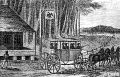
Stage coach of 1795 from "Weld’s Travels."
In 1818, a stage line ran through Merion from Chestnut and 6th Streets in Philadelphia. It passed through Merion, Gulph Mills, King of Prussia, Valley Forge and Phoenix Iron Works to French Creek Boarding School...one day’s trip. The stage ran, outbound, on Tuesday, Thursday, and Saturday and returned to Philadelphia on Monday, Wednesday and Friday. The fare was $1.75...or 6 cents a mile.
The fast stages imposed great stresses upon the narrow, rutted roads, as there were schedules to be maintained and prestige for cutting time off a run. Different stages also raced between stops, to be the first to arrive at a wayside inn.
There was a hierarchy of the establishments: the inns served the stage traffic and other places served the drovers of the mammoth Conestoga wagons. Innkeepers jealously guarded their reputations, since losing the patronage of one of the stage lines could lead to ruin in the competitive marketplace.
A Conestoga wagon was a sturdy, colorful covered wagon named for the Lancaster county town where it was first built. 25 feet long, its canvas top supported by huge hoops 11 feet high, the vehicle weighed over 3,000 pounds. The massive wagons were made of white oak and poplar with a sag in the middle to take the strain off the ends. Sturdy iron wheels and axles were needed for the rough roads to be traveled and the streams to be crossed.
A wagon cost $250, but the six powerful horses that drew it were worth $1,000. Each horse sported colored headbands and ribbons and a set of varitoned bells which heralded the rumbling approach of the Conestoga.
It is not difficult to imagine the strain of pulling heavy loads up and down the numerous hills of the area. Many teams had at least one lame or sick animal, and the casualties along the road were many. Furthermore, the cost for stabling a horse overnight was the same as lodging for a person, so it was not uncommon for the teams to be left out in all kinds of weather.
Wagonmasters were a tough, hard-bitten, resourceful class of men: seasoned by weather and experience, ready to fight for a load, not hesitant to force another wagon off the road in a right-of-way dispute. Unlike the more stylish stagecoach drivers, these men wore rough homespun and leather and a flat wide-brimmed hat to give some protection from sun and rain. Pockets would bulge with cheap cigars called "stogies," presumably a corruption of Conestoga. This rough era came to an end when steam locomotives ushered in a new age of progress.
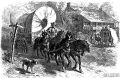
More Conestoga wagon teams.
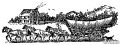
Conestoga wagon teams.
As a unit of measure, the mile dates back to Roman times. The Latin is "milia passuum," meaning a thousand paces. The Romans also erected stone markers at mile intervals to notify the passerby of distances covered or the number of miles to go to reach their destination. These markers were conveniently called milestones. Distances from Rome were measured from the "gilded column" in the Forum which was inscribed with the names of the principal roads and the distances of the major cities.
Colonial Landmarks. Early in American history, Philadelphia was a major city in Pennsylvania. Roads radiated in all directions like a spider’s web to the surrounding towns. Philadelphia’s equivalent of the Roman "gilded column" was located at the old Philadelphia Court House which stood on Market and Second Streets.
It was Benjamin Franklin, the Colonial Postmaster, who insisted on having milestones erected, because they expedited mail delivery by keeping the postal riders on schedule. These milestones also became popular as a way of identifying the location of a property. For example, on the 1752 Scull and Heap Map, under the "Table of Distances," we find the Merion Meeting House listed as having the address of 7—5 (7 miles and 5 furlongs). Many inns were intentionally located near these markers because the innkeepers thought milestones brought them good luck and fortune. Finally, along the turnpike roads, these markers were a means for seeing that no person was charged for more miles than he traveled.
As a note of interest, Benjamin Franklin is credited with the invention of the "odometre." This ingenious mechanical device was used to determine the exact location for each milestone. The "odometer" was attached to a carriage wheel and as it passed over the road it recorded the distance of a mile.
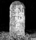
The Three Roadways. Granite milestones continue to mark the distance to Philadelphia along the rights-of-way of our three local roadways: Old Lancaster Road (now Montgomery Avenue), Old Gulph Road and Lancaster Road. There are a total of fourteen milestone sites that exist in Lower Merion. Let’s take a brief look...
Old Lancaster Road. One of the oldest roadways in the state, Old Lancaster Road began as an Lenape foot path. After the arrival of the Welsh, the Religious Society of Friends (Quakers) established their Merion Meeting House and used this path to link them to the their fellow Quakers who lived and worshipped at the Great Meeting House at Second and High (Market) in Philadelphia. A short time later this path was extended in a westwardly direction to connect to the Radnor Meeting House.
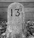
There is no clear documentation when
milestones 7 through 10 were installed, but they were probably in place
by c. 1740. They were erected on the north side of this roadway and were
inscribed with the appropriate mileage numeral on the front side.
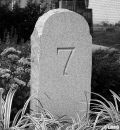
Old Lancaster #7
By the entrance to the municipal parking lot near the intersection with Levering Mill Road.
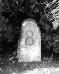
Old Lancaster #8
By the front door of Beneficial Savings Bank near the intersection with Gordon Ave.
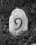
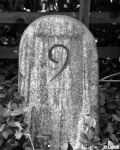
Old Lancaster #9
At 349 East Montgomery Ave. which is between Wister and Owen Roads.
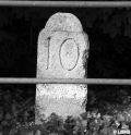
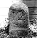
Old Lancaster #10
At 111 West Montgomery Ave. near the intersection with Woodside Ave.
"Remove not the ancient landmark, which thy fathers have set"—Proverbs 22.28
Old Gulph Road. Old Gulph Road, an extension of Old Lancaster Road, was constructed to enable the Welsh Quakers easy access into the Mill Creek Valley region. In the valley or gulph (a hollow place in the ground), they constructed their mills along Mill Creek which was used to power their grist, lumber, woolen, paper and powder mills.
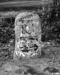
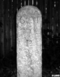
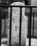
Milestones 9 through 13 were erected on the north side of this roadway in c. 1793 by the Mutual Assurance Fire Company of Philadelphia as a price for their charter from the Penn family. Because of their unique design, this group of milestones is commonly referred to as "William Penn Milestones." On the front side, which faces the roadway, there appears the appropriate mileage numeral, while on the back side are three raised cannon-balls on a bar within a shield which is the coat-of-arms of Admiral Sir William Penn.
Old Gulph #9
At 201 Old Gulph Road across from the entrance to the Friends’ Central Lower School.
Old Gulph #10
By the entrance to the ford at the intersection with Williamson Road..
Old Gulph #11
At 703 Old Gulph Road near the intersection with Morris Ave.
Old Gulph #12
Near the gatehouse at Beaumont Retirement Community between Great Springs Rd. and Ithan Ave.
Old Gulph #13
On Old Gulph Road at the corner property of 104 Mt. Moro Rd.
Lancaster Road. The War for Independence was over and the country was focused on opening up new territories to the west. Traffic was so heavy on the Old Lancaster Road that there was a demand for an additional road between Philadelphia and Lancaster. This led to the construction of the Lancaster Road (Route 30), which was completed in 1794 and called "The Great Road to the West."
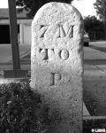
Milestones 5 through 9 were erected on the north side of this roadway in 1795 by Joseph Price who was awarded the contract by the State of Pennsylvania. It’s important to note that the Lancaster Road milestones used a different starting point of reference from the other two roadways. These marked the distance to the Market Street Bridge (30th Street) at the Schuylkill River. Therefore, there is a difference of two miles in their measurement to Philadelphia. On the front side, which faces the roadway, appears the appropriate mileage numeral followed by "M to P" or "Miles to Philadelphia."
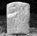
Lancaster Ave. #5
At St. Charles Seminary across from the main entrance to Lankenau Hospital.
Lancaster Ave. #6
Between Stanford Drive and Clover Hill Road.
Lancaster Ave. #7
At the intersection with exit roadway from the Township Administration Building.
Lancaster Ave. #8
At 423 Lancaster Ave. at the intersection with Llanalew Road.
Lancaster Ave. #9
On the south side of the road in front of Ludington Library.
| <-- Previous | LMHS Home | Contents | Order Book | Next --> |