
| <-- Previous | LMHS Home | Contents | Order Book | Next --> |
"Narberth, the hole in the donut," "Narberth, the heart of the Main Line." Such sayings hardly convey the true spirit of Narberth...the "hole" referring straightforwardly to the borough’s agreeably "landlocked" position totally surrounded by Lower Merion Township, and the "heart" quoted from a familiar boosterish mid-1994 bumper sticker seemingly offering a riposte to the persistent snobbish remark that Narberth is just too egalitarian to be considered a typical Main Line town. Or the version that gets more quickly to the point, insisting simply that Narberth is not on the Main Line. Yet the question that more regularly rivets public attention now that Narberth has become a trendy address in the 1980s and ‘90s is that several other Lower Merion communities also considered adopting independent rule. So how come Narberth actually went ahead and did it, and what has this meant overall?
Creation here of a town in 1881 was as much tension as energy...a move intended at the outset to bring neighborhood order out of chaos during the area’s disruptive race track era. Although introduction of Narberth’s borough government in 1895 (to replace more conventional, broader-based township rule) appears in principle a dramatic change of approach, it was a natural extension of preoccupations developed within a couple of new community-minded residents’ organizations and coming to a head in the early 1890s.
For this period had been preceded by a decade of speculative starts and stops at constructing different kinds of housing for a new town. Once this bridge to independent rule had been crossed and the borough, occupying 0.52 square miles, existed, Edward R. Price’s original goal of starting a town on his farm might have seemed like a mission accomplished. Actually, much still remained to be done to make the new municipality fully operational. And those were the tasks of the first fifty years.
Narberth’s proverbial smalltown feel is dependent on many factors....especially the closely knit character of its neighborhoods where siblings and cousins often settled near one another during that first half century. Also the rare superabundance of community organizations, then and now, that people may join here compared with fewer (if larger) such groups in neighboring townships.
Another enhancement of Narberth’s cohesiveness: this is virtually the only Main Line community with its town center along the same main street on which its rail station is directly located.
The period before World War I saw the buildup of that town center, and also construction of the first and biggest wave of hundreds of small and semidetached houses on the north side of town. Development of the south side continued at a slower pace.
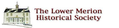
Overview of Edward R. Price farm, looking north to Montgomery Avenue at Old Gulph Road, which stretches down at right (not yet renamed Narberth Avenue at this time, 1883). Fenced cowpath in foreground soon became Price Avenue. The nucelus of Price’s town of Elm is under construction in the foreground here, at a site which has since become Montgomery Court Apartments. The Philadelphia & Columbia Railroad passed over about where the cowpath is.
Ancient stone smithy owned by the General Wayne Inn opposite it, said to be where General Cornwallis’ horses were shod. Replaced by gas station in the 1920s.
Rees Price House built 1803 by Joseph Price. Edward R. Price, grandson of Rees Price, who founded the town of Elm, was born, lived all his life and died in this house.
The General Wayne Inn appeared on a 1930s postcard.
Libertyville House, 1226 Montgomery Avenue. Cellar contains under front door the huge base of chimney of ancient log cabin formerly linked to two bay Federal era stone wing at left; wooden Victorian unit replaced cabin; mid 19th century justice of peace’s lockup is in the cellar; Liberty Pole believed raised here in "quasi war" with France.
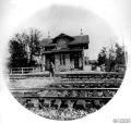
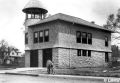
Elm Station, three level stone building north of the tracks, 1870, with ticket office, waiting room on platform level, living quarters for station master’s family above, and business offices on street level. Joseph M. Wilson, architect. Razed.
Small wooden house of reputed "witch" Betty Conrad; late 18th century with Victorian additions; razed 1980.
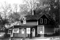
The earliest settled part of Narberth, believed to be where Swedes traded at the "ancient Indian spring" with the Susquehannock Indians (a breakaway tribe of the Iroquois). Libertyville at its center still has one of its two known early log cabins, this one plastered over. Also traditionally thought to be the site of the raising of a patriotic Liberty Pole denoting a Federal era international incident on the high seas that may have given the surrounding area its first name, Libertyville.
The heart of this old district had been along the Montgomery Avenue in the vicinity of the present Hansen tract houses.
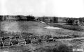
19th century slaughterhouse at Libertyville; many later reuses, but eventually demolished for a housing subdivision.
In this vicinity was the tiny wooden house of the reputed "witch" Betty Conrad, mentioned in Joseph Price’s Diary.
A small densely settled area with a separate identity since colonial times when a good water supply made it habitable, and sandwiched between exceptionally large farms, that Libertyville nucleus long functioned as a service area for its agricultural neighborhood. By the mid-19th century, it featured a slaughterhouse widely used by the region’s farmers. That relic survived long afterward as a shop for high quality Arts & Crafts objects and garden accessories.
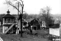
View to northwest from Narberth Station. Signal tower at left; dormer window of new business block visible behind telegraph pole; rear of new general stores at center on the main street houses. Photo c. 1898; sign of John B. Clothier, Goodman & Clothier, developers.
The next generation after the borough’s founders to take leadership began with a flourish 1914. New ideas proposed focusing on problem solving and civic beautification so that the municipality and a new civic association should shoulder such responsibilites cooperatively. This second generation momentum soon launched a rare Progressive Era initiative. A Garden Cities model community (Narbrook Park) was established on a partly swampy tract of land...a project lately referred to as Pennsylvania’s first conservation subdivision. Also in 1914, the cherry blossom was chosen as Narberth’s town tree and planted plentifully at key locations in full public view...our front street, Montgomery Avenue and along Penn Valley’s Braeburn Lane in the township. Thus a tradition was launched of city folk coming out to Lower Merion and Narberth to view cherry blossoms and crabapples blooming in April.
The borough’s population having tripled by the end of the first decade, the numbers kept climbing steadily, reaching their peak of just under six thousand residents around 1950. Construction of the main playground had been authorized by the townspeople in the mid 1920s, which is considered early. And a community building complex housing the library, a women’s club and the American Legion post was constructed adjacent to the playground around the same time. A popular fireworks tradition dates back to 1922 and the Memorial Day parade is another regular event, sponsored by the Narberth Civic Association.
The suburbanization trend following World War II left Narberth edgy and wanting to catch up. Here was a community with scarcely any open land suitable for new construction. So the town fathers welcomed developers who started demolishing big corner Late Victorian houses and replacing them with apartment blocks and closer to downtown, with low-rise commercial buildings.
There has to be something encouraging in the fact that families with young children are pouring into this old-fashioned town which, besides its long history of strong civic life and civic betterment, happens to be the third most densely settled residential community in the state. For it means that lots of independent-minded young people, by coming here, are willing to swim upstream against a swift current now sweeping so many Americans into new tract houses on ravaged farm landscape.
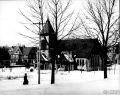
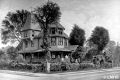
Narberth Presbyterian Church, built of Holmsburg granite, 1897. J. Cather Newsom, Architect.
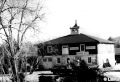
Elm Hall, completed 1899. Built by members of Narberth Fire Company, mostly with donated funds; upstairs rented for municipal offices; used, with modifications, to 1960.
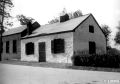
Oldest house in Narberth, now called #610 Shady Lane, is in the heart of the old Libertyville district. It includes a log cabin at right. John Kernan, his wife, three daughters and a friend pose for this 1911 photograph. Kernan bred trotting horses here on his farm.
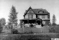
Vauclain-Barrie House on Price Avenue, 1883; only surviving house that Edward R. Price personally built for his town of Elm; currently a Methodist parsonage.
Town of Elm. Edward R. Price founded the Quaker-friendly town of Elm on his hundred-acre farm near Elm Station in 1881, commissioning large mansions (designed by Isaac H. Hobbs) to be constructed there for a start ...and inviting an experienced town-builder Samuel Richards (a grandson of naturalist John Bartram), to settle there with his family and keep a close eye on things. Even so, development was initially sporatic, but picked up toward the end of the decade with a flood of somewhat smaller Late Victorian houses on narrow lots. Eventually Richards had the satisfaction to place his John Hancock on the successful petition to sever connection with Lower Merion Township and declare Narberth‘s status as an independent borough in 1895.
Although other towns considered independence, Narberth went the distance because it had a structure already in place to enable it to reach that goal. It was largely due to Price’s earlier initiatives as a town-builder and the involvement of his proactive developer, Samuel Richards and his associates, most of the major players being Quakers.
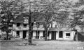
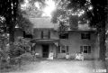
August H. Mueller House, "Romar-Florem," 1891, residence of Narberth’s first elected burgess (mayor) in 1895. He bought the house new. Now razed.
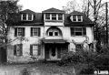
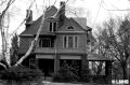
Edward Forsythe House, designed by Charles W. Bolton, architect, 1888. Built for the town of Elm, it stands, much remodeled, between Price and Wayne Avenues.
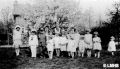
May Day, c. 1927, in Narbrook Park.
Narbrook Park. A model community built by a civic association, it is an uncommon concept in the suburbs. Yet Narberth Civic Association undertook such a project in 1914, breaking ground in 1915 for what was to feature preserved open space surrounded by well-designed small houses...35 of them, as it turned out...on 14 acres.
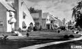
Promotional postcard, c. 1920, for Narbrook Park, created and developed by Narberth Civic Association.
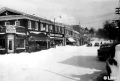
Haverford Avenue, Narberth business district’s main street, c. 1950s, looking east.
| <-- Previous | LMHS Home | Contents | Order Book | Next --> |