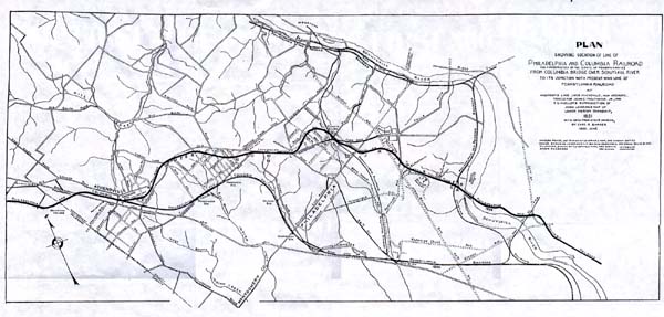
| A | South slope (still traceable) of embankment on curve leading from Columbia Bridge, east of Junction Railway, toward the Inclined Plane |
| B | On east side of Junction Railway, looking west toward that Railway - End of square stringer or tie, with long round iron ball, bent to a semicircle - Square stone block - These two perhaps in place |
| C | Stone tie and three pairs of square stone blocks, at south corner of row of dwellings. |
| CE | Line of inclined plane, well marked by excavation and embankment, filled with undergrowth, but without notable relics. Park trolley line occupies stretch D-E. |
| F | Remains of double track on curve, just south of Park trolley track, south of Junction station. East track on stone stringers; west track on square stone blocks. Detached pair of square stone blocks in place near by, indicating curve to the right. Stringers in vicinity, out of place. Long grass cut, and earth covering removed by order of Mr. Alan Carson, Chief Engineer to Park Commission. |
| G | South side of Midvale Ave., opposite Methodist Home for the Aged. Double track as in F, but on tangent. |
| HJ | From H to J, the Columbia R.R. line followed the present line of Conshohocken State Road, now Conshohocken Ave. The stone blocks were thrown to the south side of the new highway, where they still remain, in a line marked by trees and shrubbery. |
| JK | From J to K, the Columbia R.R. line kept to the west of Conshohocken Ave., in part of this distance being directly over the present tracks of the Schuylkill Division of the Pennsylvania R.R. |
| K | East and west slopes of side-hill cuts, on east side of excavation of Schuylkill Division, Pennsylvania R.R. and south of highway bridge carrying Montgomery Ave. over said division. Blue print, furnished by Pennsylvania R.R. Company engineer office, shows center line of Columbia R.R. crossing center line of Schuylkill Division, Pennsylvania R.R. in axis of said highway bridge and near the middle of its length. |
| KL | From K, the Columbia R.R. line seems to have followed the present line of Bala Ave. to about where it now crosses Bryn Mawr Ave. Thence it followed a tangent to a point in the rear of the present house of the Union Fire Association. Thence it curved to the right, passing under the old Ford Road, which crossed over the R.R. on "Bowman's Bridge." This curve brought the R.R. line to a tangent at a point, L, where the line of the south side of Montgomery Ave. (then called Old Lancaster Road) produced, reaches what is still called Old Lancaster Road. |
| | At the N.E. corner of Ford Road and Parson's Ave., Mr. J.S. Parsons has built a corner post containing several of the old square stone R.R. blocks. |
| | The changes in roads at Merionville seem to have been roughly as follows - Before the R.R. abc, Old Lancaster Road. adef, Ford Road. But between d and e, Ford Road (see Levering's Map) was "kinked" to dbe in order to make it cross the R.R. nearly at right angles and de was abandoned, the line of Ford Road, after the building of the R.R., thus becoming adbef. The portion of db of Ford Road now coincides with the line of Levering Mill Road, gdb. When Montgomery Avenue was created, it took abc from the Old Lancaster Road, but later bf was called Mongomery Avenue, and bc again became Old Lancaster Road. cd is now called Ford Road, bc, Old Lancaster Road, abef, Montgomery Ave. and gdb Levering Mill Road. |
| LO | From L to O, the Columbia R.R. line followed the south side of Old Lancaster Road, now Montgomery Avenue. At M, just east of Thourun's Lane (which crosses a small run on a bridge of three (?) arches) is the south face of an arched stone culvert. At N is the "Federal Spring." Many of the old stone R.R. blocks are here built into the retaining wall on the south side of Montgomery Ave. Beyond O, the R.R. line curved gently to the left. |
| P | At P the R.R. line passed over the site of a frame stable building. At the SW corver of this stable, the top course of a box culvert is seen. |
| PQ | From P to Q, the line (easily traceable by pairs of tall trees and by underbrush on the old low embankment) follows the south property line of John Albrecht's triangular lot. |
| QR | Between Q and R the line has been entirely obliterated by the building operations which produced the newer part of Narberth. In general, the R.R. line crossed the lines of the present streets at angles of about 45 degrees, to its crossing with the present Essex Ave., just north of the Narberth Public School. Beyond this it probably followed nearly the curve of Essex Ave. Stone blocks (out of place) are seen at the corners of Hamden and Woodbine Aves., Woodbine and Narberth Aves., and Narberth and Price Aves. |
| RS | Between R and S, remains of a low R.R. embankment are seen, with remains of a box culvert where the line crossed a small run. |
| T | In a driveway at T are seen, well preserved and well exposed, 3 pairs of the square stone blocks. |
| U | At U the R.R. crossed the Old Lancaster Road (now Montgomery Ave.) which was bent for the purpose crossing the R.R. at right angles. The resulting "kink" (shown on Levering's map) has been removed. From U to the east side of Montgomery Ave., the line is easily traced by old trees, underbrush and the remains of a shallow cut. |
| VW | From V to a point just east of the Lower Merion High School at W, the R.R. line lies a little to the northward of Montgomery Ave. (then Old Lancaster Road). It was here mostly in shallow excavation, where many square stone blocks are still in place. The line is easily recognizable from Montgomery Ave. by the double line of trees which its presence preserved from destruction. |
| WX | Between W and X, the R.R. line described a curve of some 75 degrees to the right, ending at about the present Thompson Avenue, a little south of the east end of Coulter Ave. In the yard of Mr. Swartz, at X, is a stone block, with chair mark, apparently nearly in place. From X, the R.R. line lay a little to the south of the present Coulter Avenue, probably meeting it and the present main line of the Pennsylvania Railroad where the two now intersect, at Y. |
| | The portion of the Philadelphia & Columbia R.R. from A to Broad and Vine Streets was sold by the State Canal Commissioners to the Philadelphia and Reading R.R. Company Dec. 31, 1847 for $243,200. |
| | An Act of 1851, April 15, Authorized the Canal Commissioners to sell the line between A and Y, and it was sold to the Philadelphia and Reading R.R. Company for $12,000 or $16,000 according to different accounts. A&P Roberts afterward bought part or all of the rails on AY for use as scrap in their mills. |