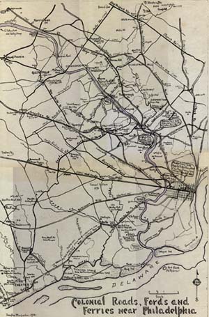
Colonial Roads, Fords and Ferries near Philadelphia.
Drawn by Dr. Douglas Macfarlan in 1934. (copy height 23" x width 18")
low-resolution
image of the map (220K)
high-resolution
image of the map (584K)
Drawings of landmark buildings on the map
The King of Prussia Tavern
- formerly at Gulph and Swedesford Roads
Drove Tavern
- Broomall
Radnor Meeting House
- 1718 - Conestoga Road at Ithan
The Schuylkill Bridge at Callowhill Street
Old Saint David's Church
- Radnor, south of Devon on Church Road
Octagonal School House
Near Newtown Square
Birthplace of John Morton
Bluff and ravine on East side of Schuylkill River
- South of Laurel Hill Cemetary - the location of Robin Hood Ford
Caleb Pusey House
, Upland. The oldest house in Pennsylvania
Spring Mill
- 1729
Mendenhall's Ferry
- from the West Side of the Schuylkill (adapted from an old Birch print) Provest Smith's "Octagonal House" at the falls is seen in the center on the opposite bank
Old Bridge of Floating Logs
at Gray's Ferry
Birthplace of David Rittenhouse
- Roxborough
Avondale
, the Leiper House on Crum Creek - 1785